After pathetically failing to keep this blog up to date during 2014, I am hoping that 2015 will see me with a new resolve to ensure that I keep things up to date.
One thing that IS going to happen is that Gill and I are determined that we will complete the 1000 mile challenge. More details to follow but we hope to set up a charity page so that people can donate to DiabetesUK if we manage to get anywhere near the required mileage per. week/month/year.
Check back in a couple of weeks; once we've got started !!
Wednesday, 17 December 2014
Monday, 17 February 2014
Buttermere and Loweswater

Saturday/Sunday 15th Feb 2014
Saturday - 7.17 km (4.46 miles) - 1hr 49 min
Sunday - 6.3 Km (3.91 miles) - 1hr 37 min
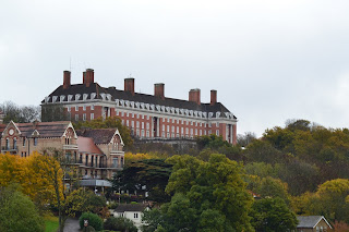
To mark the occasion of my brother-in-laws 60th birthday a group of us met in the Lake District to both celebrate Roy's birthday but also to re-create two walks we did 10 years ago when he was (obviously) 50!

The walk itself is very straightforward and well marked. From the pub you walk down towards the lake and follow the very clear path across the top of the lake and then through Burtness Woods (an area where red squirrels are pre-dominant, although none were about at this time of the year). Whilst the conditions may not have been conducive to driving they certainly enhanced the scenery with all the mountain tops covered with a dusting of snow.
At the bottom end of the lake the path is, again, very well marked and well trodden in this weather and leads across to the road before turning and heading back towards Buttermere itself and descending onto the lake shore for the return and a very welcome drink in the warmth of the Bridge Inn.
Sunday
Thanks go to the Coffee Kitchen in Cockermouth who provided us with a superb buffet on Saturday evening and allowed some party members to furnish Roy with birthday presents. After a good night's sleep we all met up at Loweswater on the Sunday morning for another short walk and the traditional (??) pub lunch.

Some photographs of the weekend are available from the link.
Postscript
I realise that it is a long time since I updated this blog. 2013 was an interesting year with redundancy, retirement, selling a house, buying a house, becoming grandparents -- as you can see it was rather busy !! Hopefully, 2014 will be a little less hectic, although looking at my diary that doesn't seem to be the case at the moment - we have two weddings to attend, one of which is my daughter's, the other in Spain. We also have a number of trips planned, including a week in Italy in the not too distant future. Hopefully, I can become a bit more disciplined and keep this blog up to date when we do get the chance to go walking!!
Sunday, 6 January 2013
Nocton to Heighington
Sunday, 6th January 2013
14.6km (9 miles) - 3hrs.

 At the end of the path we turned left past the village school and took the next left into a cul-de-sac with an easily spotted footpath sign at the end (GR TF065632). Here we met the worst of the recent weather as we had to cross the world's wettest field (well, paddy fields excepted !).Thankfully, the field wasn't that large and we soon met the appropriately named Green Lane (GR TF076637). A straightforward dog-leg brought us out at the wonderfully named Wasps Nest (GR TF080647).
14.6km (9 miles) - 3hrs.

A misty day in Lincolnshire !! I know that most people are expecting a walk in the Yorkshire Dales and surrounds but my daughter and husband have just moved into the village of Heighington, just outside Lincoln and, as we were visiting we planned and did this liner route which started in the village of Nocton and ended back at their house. Well done to both of them for walking this distance (they're not normally walkers) and well done to Gill who hasn't been too well over the festive season but was glad to get back to walking.
As I said this was a misty walk - at one point we thought the sun might break through but, instead, the mist actually got worse as we progressed. Sadly, this didn't make for spectacular views and even less spectacular photography.
Anyway, the walk (as stated) began in Nocton (GR : TF057643) and soon picked up a green lane (GR TF058641) which headed away from the village towards Dunston, another of the small villages that seem to dot the countryside around Lincoln. The path (although I describe it as a green path) was actually partly metalled, so it was easy going.
 At the end of the path we turned left past the village school and took the next left into a cul-de-sac with an easily spotted footpath sign at the end (GR TF065632). Here we met the worst of the recent weather as we had to cross the world's wettest field (well, paddy fields excepted !).Thankfully, the field wasn't that large and we soon met the appropriately named Green Lane (GR TF076637). A straightforward dog-leg brought us out at the wonderfully named Wasps Nest (GR TF080647).
A short stretch of road brought us to the edge of a dyke and another wonderfully named wood called Bottom Barff (I must begin to look up some of these Lincolnshire phrases !) . The end of this stretch joined up with another green lane before we skirted Burnt Wood and Potterhanworth Wood along the top of Car Dyke. Eventually this brought us out a Potterhanworth Booths (GR TF074679) alongside the sadly closed Plough Inn.
Unfortunately, the next couple of kilometres were along a quite busy road but we soon turned off the main road at Branston Booths (GR TF061691). The final stretch was along small country lanes turning down Brinkle Spring Lane and back in Heighington.
A nice walk - but no hills of course !! We have decided that we will go around the area later in the year when we can actually see further than 200 metres in front of us. A selection of photographs are available from this link
Sunday, 11 November 2012
Thames Walk
Saturday, 10th November
7.46 Km (4 1/2 Miles) - 1hr 26m

 and some rural views both down and across the river. Start by going up the road, past the East Stand to the roundabout next to the Tesco supermarket. Continue along Mogden Lane until you reach a main road. Cross this to pick up Northcote Avenue until, once more a major road is encountered. Again, you cross this road and take a slight right to dogleg down another road (sorry, I've forgotten the name). This street is followed until, almost by magic, the river appears next to Richmond footbridge.
 At this point the vistas open out to reveal Ham Hill on the far side of the river and shortly afterwards Marble Hill House on the path side of the river. Not much further on the route diverts away from the river before emerging at a seating area next to the river at Twickenham itself. Here we turn away from the river to the very busy Twickenham town centre and wander up to the Station where the stadium, and the walk end, comes into view.
7.46 Km (4 1/2 Miles) - 1hr 26m

So, the rugby season is upon us and, more importantly the QBE Autumn Internationals means that for four weekends I will be spending the weekend at Twickenham. One of the problems (!) with these weekends is how to fill the void between breakfast and lunch ! Thankfully, walkit.com provided this walk at some point during the last season. Sadly I didn't record the walk then but am happy to share it now.
Luckily, we are able to stay in the Marriott Hotel which is part of the South Stand at Twickenham so this is where the walk starts from. The route is quite straightforward and mixes the urban with the river Thames
 and some rural views both down and across the river. Start by going up the road, past the East Stand to the roundabout next to the Tesco supermarket. Continue along Mogden Lane until you reach a main road. Cross this to pick up Northcote Avenue until, once more a major road is encountered. Again, you cross this road and take a slight right to dogleg down another road (sorry, I've forgotten the name). This street is followed until, almost by magic, the river appears next to Richmond footbridge.
From this point onwards the route is pretty straightforward as the path sticks close to the river, although it is at one point hidden from view behind houseboats. The only difficult stretch is where the route crosses Richmond Road. Here you need to pick up Cambridge Road before veering sharp left to pick up the river path once more.
 At this point the vistas open out to reveal Ham Hill on the far side of the river and shortly afterwards Marble Hill House on the path side of the river. Not much further on the route diverts away from the river before emerging at a seating area next to the river at Twickenham itself. Here we turn away from the river to the very busy Twickenham town centre and wander up to the Station where the stadium, and the walk end, comes into view.
This is a nice walk, and just the right length to "waste" an hour or so away from rugby! I was lucky on the day that I walked as it had been raining quite heavily earlier in the day. However, I was able to complete the walk without getting wet. Some photographs of the walk give a flavour of the surroundings !
Oh ! and for the record England beat Fiji in the international that followed !
Sunday, 4 November 2012
Calder & Hebble Canal
Sunday, 4th November 2012
6 miles (9.78 km) - 2hrs 15min
MAP : OL21 South Pennines

A dry but very cold day. When I left home the temperature stayed a 0c and the fog was thick and cloying. However, the mist did lift slightly by the time I got to the starting point, as did the temperature.
This walk was taken from Country Walking Magazine and downloaded from their companion website Trailzilla. I have to say that finding walks/activities on Trailzilla is not the easiest, or most intuitive but at least once found the GPS downloads are first rate.
The most difficult part of this walk was finding the start position (GR SE 095223) since the car park is not well marked. However, I did find it and immediately started walking in the wrong direction !! I put it down to the slightly confusing directions, I'm sure the author would disagree ! Anyway, thanks to some helpful cyclists I eventually got myself on the right tracks and have to say that the rest of the walk is simplicity itself. Put simply, once on the towpath, stay on the towpath !!
 The colours at this time of the year were spectacular and the walking easy and flat. I was quite surprised at how many people, both walkers and cyclists, there were out and about on what was a bitterly cold morning. It is good to see that many more people these days take the opportunity to get outdoors.
As I say the route is straightforward, along the towpath until you encounter Sowerby Bridge marina (opposite GR SE065236) where quite a few canal boats are moored. Just past the marina you cross the canal and double back upon yourself until meeting the Navigation Inn (GR SE067237). Here you leave the canal and cross the bridge to a road that leads through some pretty ugly industrial estates until the River Calder is encountered (GR SE070236) and you escape the industrialisation for a path running alongside the river.
One of the features of this first part of the walk is the proximity of houses and roads which, whilst close do not intrude on the walk itself. The second part of the walk escapes into a more rural aspect, although the views remind you of where you actually are.
After following the river the route then cuts off and under a railway bridge (Hollas Bridge GR SE076231). Here I picked my one and only cache of the day, nicely hidden by a fence post close to the bridge. From the bridge the route then cuts quite sharply uphill giving some good views down and across the valley to the Wainhouse Tower, a famous folly that dominates the skyline. Sadly, the mist was still hanging around and I'm sure the photographs don't do the views justice. After climbing the side of the valley you then descend sharply ending up alongside Old Rishworthians Rugby Club (GR SE084223). A short stride takes you back under the railway bridge to rejoin the canal and back to the start point.
A I mentioned the walk started in thick, freezing fog but I'm glad to say it had lifted slightly by the end of the walk. Most spectacular at this time of the year were the autumn colours and the fact that the walk leads through some fairly built up areas which are unobstrusive and do not spoil the walk at all.
Well, I'm off to Twickenham during the next month. I may get some walking done prior to the matches kicking off and will try and post some of them up here.
6 miles (9.78 km) - 2hrs 15min
MAP : OL21 South Pennines

A dry but very cold day. When I left home the temperature stayed a 0c and the fog was thick and cloying. However, the mist did lift slightly by the time I got to the starting point, as did the temperature.
This walk was taken from Country Walking Magazine and downloaded from their companion website Trailzilla. I have to say that finding walks/activities on Trailzilla is not the easiest, or most intuitive but at least once found the GPS downloads are first rate.
The most difficult part of this walk was finding the start position (GR SE 095223) since the car park is not well marked. However, I did find it and immediately started walking in the wrong direction !! I put it down to the slightly confusing directions, I'm sure the author would disagree ! Anyway, thanks to some helpful cyclists I eventually got myself on the right tracks and have to say that the rest of the walk is simplicity itself. Put simply, once on the towpath, stay on the towpath !!

As I say the route is straightforward, along the towpath until you encounter Sowerby Bridge marina (opposite GR SE065236) where quite a few canal boats are moored. Just past the marina you cross the canal and double back upon yourself until meeting the Navigation Inn (GR SE067237). Here you leave the canal and cross the bridge to a road that leads through some pretty ugly industrial estates until the River Calder is encountered (GR SE070236) and you escape the industrialisation for a path running alongside the river.
One of the features of this first part of the walk is the proximity of houses and roads which, whilst close do not intrude on the walk itself. The second part of the walk escapes into a more rural aspect, although the views remind you of where you actually are.
After following the river the route then cuts off and under a railway bridge (Hollas Bridge GR SE076231). Here I picked my one and only cache of the day, nicely hidden by a fence post close to the bridge. From the bridge the route then cuts quite sharply uphill giving some good views down and across the valley to the Wainhouse Tower, a famous folly that dominates the skyline. Sadly, the mist was still hanging around and I'm sure the photographs don't do the views justice. After climbing the side of the valley you then descend sharply ending up alongside Old Rishworthians Rugby Club (GR SE084223). A short stride takes you back under the railway bridge to rejoin the canal and back to the start point.
A I mentioned the walk started in thick, freezing fog but I'm glad to say it had lifted slightly by the end of the walk. Most spectacular at this time of the year were the autumn colours and the fact that the walk leads through some fairly built up areas which are unobstrusive and do not spoil the walk at all.
Well, I'm off to Twickenham during the next month. I may get some walking done prior to the matches kicking off and will try and post some of them up here.
Thursday, 18 October 2012
Thruscross Reservoir
Thursday, 18th February 2012
15.2 km (9 1/2 miles) - 3 hrs 45 mins
Map : OS Explorer 297 - Lower Wharfedale & Washburn Valley
 Thruscross is the highest of four reservoirs in the Washburn Valley, only a few miles from where I live. A Thursday off work gave me the chance to try the route above which I got from the Trailzilla site.
 The walk starts from the Car Park at the very top of Fewston Reservoir (GR : SE 168553). Care must be taken crossing the very busy A59, the main road between Skipton and Harrogate, to pick up Hall Lane (signed to West End). The road climbs steadily until it takes a sharp right turn. The route, however, carries straight on up a green lane that carries on the steady ascent until it meets another metalled road (GR : SE 143556). Here you turn right along Kex Gill Road until passing Burnt House on the left hand side and a footpath sign which gives on to rough pasture land.
In all honesty this was the only difficult part of the walk,although heading just to the right of West End Outdoor Centre should lead you in the right direction.
Thruscross, was the last of the four reservoirs to be built and included flooding the village of West End. The church (or chapel) was moved to higher ground, but without a congregation is now an oddly shaped outdoor centre (which I have stayed in on a couple of occasions).
From here the route is very straightforward as you follow the paths laid out by Yorkshire Water, who own the reservoir. At first the route hugs closely to the shore of the water, passing through maintained pine woods, giving off a heady mix of resin smells on this particular day. Whilst extremely muddy the going is not too tough, although care had to be taken due to the slippery nature of the underfoot conditions.
Emerging at the far end of the reservoir the route does take a detour up a fairly steep incline to cross Roundells Allotment before dropping back down to the shoreline again.
 Eventually the dam at the end of the reservoir is crossed before dropping down the embankment and finishing the walk alongside the River Washburn itself.
A slightly longer walk than I first anticipated but even though it is mid-October I managed this with just a base layer and fleece (discarding the fleece for the latter part of the walk). The light was not particularly good for photography and the photos do not, perhaps, reflect the scenery that is visible. It was however a varied walk - with hardly a soul about - taking in open moorland, the reservoir and woodland. All in all a fantastic day and my back seems to have held up, although the legs are pretty stiff !
15.2 km (9 1/2 miles) - 3 hrs 45 mins
Map : OS Explorer 297 - Lower Wharfedale & Washburn Valley


In all honesty this was the only difficult part of the walk,although heading just to the right of West End Outdoor Centre should lead you in the right direction.
Thruscross, was the last of the four reservoirs to be built and included flooding the village of West End. The church (or chapel) was moved to higher ground, but without a congregation is now an oddly shaped outdoor centre (which I have stayed in on a couple of occasions).
From here the route is very straightforward as you follow the paths laid out by Yorkshire Water, who own the reservoir. At first the route hugs closely to the shore of the water, passing through maintained pine woods, giving off a heady mix of resin smells on this particular day. Whilst extremely muddy the going is not too tough, although care had to be taken due to the slippery nature of the underfoot conditions.
Emerging at the far end of the reservoir the route does take a detour up a fairly steep incline to cross Roundells Allotment before dropping back down to the shoreline again.

A slightly longer walk than I first anticipated but even though it is mid-October I managed this with just a base layer and fleece (discarding the fleece for the latter part of the walk). The light was not particularly good for photography and the photos do not, perhaps, reflect the scenery that is visible. It was however a varied walk - with hardly a soul about - taking in open moorland, the reservoir and woodland. All in all a fantastic day and my back seems to have held up, although the legs are pretty stiff !
Sunday, 7 October 2012
Evestone Lake
Sunday, 7th October
9k (5.4 miles) 2hrs 52 mins
Map : OS Explorer 26 - Nidderdale.

What a delightful October's day with temperatures reaching about 15 degrees and hardly a cloud in the sky. It seems that recently I have started each of these blogs with an apology. In this instance it was a relief to get back to walking, and back is the operative word as I've been laid up with a bad back. Lots of pain, lots of painkillers and a complete lack of mobility. So we decided to take a shorter than usual walk and what a cracker it turned out to be !
 The walk started in the small village of Sawley, between Ripon and Pateley Bridge (GR : SE 247677). We actually had some difficulty in locating this as neither of our phones seemed capable of picking up a GPS signal. Even the handheld GPS itself seemed reluctant in the first instance to lock on to any satellites - and not a cloud in the sky !
At the south end of the village we escaped the road and walked through fields towards Lacon Hall (GR : SE 247669). After skirting the boundary of the house the route took us out to the aptly named Green Lane (GR : SE 243665). Here, looking back we had wonderful long range views across to the Hambledon Hills - a view that remains for much of the walk.
Striking out we now headed for Butterton Bridge at the bottom of Picking Gill before climbing the other side of the gill towards Warsill Hall Farm (GR : SE 234659). Again, the top of the ridge allowed long range views.
Across a couple of fields and we were into High Moor Plantation and a dead straight track which eventually brought us out and across the very busy B6265. However, our route still lay straight ahead towards a farm to take a sharp right turn that dropped us to Evestone Lake.
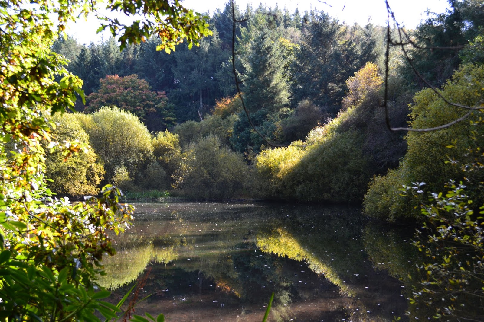
What a delightful and enchanting place this turned out to be. The lake is, I presume, man-made and I have no idea why it was created but trees seemingly grow out of rocks at strange angles and, on our visit, hardly a murmur could be heard with the water's surface unbroken and reflecting the trees that surround it.
At the end of the lake we collected our "cache of the day" before climbing steeply through Fishpond Wood to Hollin Hill Farm (GR : SE 234682). From here it was simply a case of following the signs back to Sawley.
A delightful walk which I need to attribute to Paul Hannon and his book "Ripon and Lower Wensleydale". The joy was the superb walk around the lake, the fantastic weather and the opportunity to get some walking under the belt, but, oh how I ached afterwards !
As usual a selection of photographs taken during the walk are available from this link -- just look at those blue skies !!
9k (5.4 miles) 2hrs 52 mins
Map : OS Explorer 26 - Nidderdale.

What a delightful October's day with temperatures reaching about 15 degrees and hardly a cloud in the sky. It seems that recently I have started each of these blogs with an apology. In this instance it was a relief to get back to walking, and back is the operative word as I've been laid up with a bad back. Lots of pain, lots of painkillers and a complete lack of mobility. So we decided to take a shorter than usual walk and what a cracker it turned out to be !
At the south end of the village we escaped the road and walked through fields towards Lacon Hall (GR : SE 247669). After skirting the boundary of the house the route took us out to the aptly named Green Lane (GR : SE 243665). Here, looking back we had wonderful long range views across to the Hambledon Hills - a view that remains for much of the walk.
Striking out we now headed for Butterton Bridge at the bottom of Picking Gill before climbing the other side of the gill towards Warsill Hall Farm (GR : SE 234659). Again, the top of the ridge allowed long range views.
Across a couple of fields and we were into High Moor Plantation and a dead straight track which eventually brought us out and across the very busy B6265. However, our route still lay straight ahead towards a farm to take a sharp right turn that dropped us to Evestone Lake.
What a delightful and enchanting place this turned out to be. The lake is, I presume, man-made and I have no idea why it was created but trees seemingly grow out of rocks at strange angles and, on our visit, hardly a murmur could be heard with the water's surface unbroken and reflecting the trees that surround it.
At the end of the lake we collected our "cache of the day" before climbing steeply through Fishpond Wood to Hollin Hill Farm (GR : SE 234682). From here it was simply a case of following the signs back to Sawley.
A delightful walk which I need to attribute to Paul Hannon and his book "Ripon and Lower Wensleydale". The joy was the superb walk around the lake, the fantastic weather and the opportunity to get some walking under the belt, but, oh how I ached afterwards !
As usual a selection of photographs taken during the walk are available from this link -- just look at those blue skies !!
Subscribe to:
Posts (Atom)