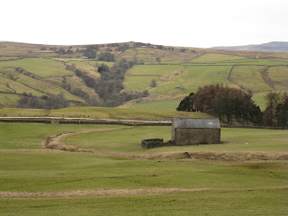
Sunday, 30 January 2011

Saxton and Towton

Sunday, 30th January.
12Km (7.46 Miles) - 2hr 47 min
Although this was a 71/2 mile walk it was relatively easy with few inclines to cope with.  This was just as well as we had both had a "heavy" night the previous evening as we celebrated John's Retirement!! 
Saxton is a small village just off the B1217 Tadcaster to Wakefield Road. It's "celebrity" is shared  with nearby Towton as the scene of the Battle of Towton, described at the "biggest and bloodiest" battles fought on English soil. Fought in 1461 as part of the War of the Roses it is estimated that some 28,000 people lost their lives and part of the walk follows Cock Beck which is said to have flowed red with the blood of the slaughtered.
We parked in the village by the church (GR SE 475368) and soon left the village behind as we headed out on the track past farms and cottages whilst on the other side was the site of the battle and, in particular "Bloody Meadow" where the Yorkists coralled the Lancastrians and infilicted heavy casualties on them. The track then takes a sharp right had turn towards Newstead Farm and the only piece of uphill work on the whole walk.
Cresting the brow of the hill brings Hazelwood Castle into view and the long, straight path heads towards it before veering off in front of the haa-haa wall and cutting through Hazelwood Park before skirting Hayton Wood.
The final stretch drops down into the valley to join Cock Beck once again and this is followed before again turning off for St Mary, Lead.  
The history of this tiny church, which stands alone in middle ofa field, is written on the back of the door. The church was first built in the 12th Century and eventually fell into direpair befoe being rennovated and re-consecrated in the 1930s.  It certainly is small with only eight pews inside.
After visiting the church one strikes through the Car Park of the Crooked Billet pub (with some self control to stop yourself visiting it ) and up the banking before dropping back into Saxton, although our way was "barred" as the farmer had ploughed the field where the footpath was supposed to run! No problem really as we just skirted the field edge to get back to the car.
A grey and overcast afternoon but a gentle walk that cleared the cobwebs and a couple of bits of history to keep it interesting !
Selection of photos available

Sunday, 23 January 2011

Skirethorns & Bordley

Sunday, 23rd January
12.5Km (7.7 miles) - 2hrs 54 Mins
Map : OL10 Yorkshire Dales - Southern Area

Another walk from the WalkingWorld website, this is no. 2755.  It is described as an easy walk, which I would disagree with as the first 5k takes you from 192 m to 370m and, although it is not a steep gradient, it is relentlessly uphill all the way.
Skirethorns is just above Threshfield on the B6265 from Skipton, take the first left after the garage.  We parked in the entrance to the quarry (SD 981638) and headed up the road signed to Malham before turning off onto Grysdale Lane, this soon meets Moor Lane and heads off up onto Threshfield Moor.
You traverse Threshfield Moor on a well defined bridleway which wends its way through old coal mining works and spoil heaps, which may be grassed over but you can still see the coal waste. Even though the weather was relatively mild, the bridleway was still icy and, in parts, quite slippery.

The bridleway eventually gives way to enclosed green lane (but still going upwards) before dropping steeply towards Bordley Beck.  Bordley itself is really only a collection of farm buildings (and a farm!) and here, you turn onto asphalt road and a steep climb before turning on to Malham Moor Road.
In not too long a distance the road is left and the route takes you through the delightful Cow Close Wood and drops through the caravan site and Wood Nook before bringing you out on Wood Lane.
The final section is a detour around the back of the quarry before leading back out quite close to the quarry entrance where the car was parked.

It was wonderful to be back in Wharfedale, which I always consider to be my spiritual home, after last weeks rambling in Nidderdale.  This was a walk that took in high, heather covered moorland along with some wonderful Dales pastures and the final section through bracken and woods.  As I said at the start, although billed as an easy walk, both Gill and I think it requires re-classification as a Moderate ramble.  By the way we've walked nearly 30 miles in January (with another weekend to come).  Despite the cold and frosty weather we've pretty lucky given that we've managed to avoid walking in the rain !

Collection of pictures here

Sunday, 16 January 2011

Pateley Bridge & Smelthouses

Sunday, 16th January
12.4 km (7.7 miles) 3:00 hrs
Glorious Nidderdale in glorious rain !!  Although to be fair the temperature was nearly 10 degrees, so it didn't feel cold at all.  This is walk no. 4473 from the WalkingWorld website,described as a "moderate" walk I think all the "moderate" bits come at the beginning which is a pretty steep pull out of Pateley Bridge itself.  However, the reward was a visit to St. Mary's Church.  This ancient but now preserved site dates back to the 14th Century and, above all, it is the cemetary that receives the plaudits. After a short stay amongst the yew trees, we plodded on (and up) stopping for some spectacular views down across Pateley Bridge itself also up Nidderdale.

The route, at this point, follows the contour lines and is fairly level, although there are a couple of pulls up the hill and the world's wettest bridleway, or so it seemed as we dragged ourselves up through the mud !


Eventually, the going got better as we dropped down to the woods above Smelthouses and took a break for a spot of lunch.  Then it was down through the woods to cross the main road near Low Laithe to pick up the banks of the Nidd.  The final section simply hugs the bank of the river to return you back into the centre of Pateley Bridge.
Whilst this was only 7 1/2 miles, I have to say it felt longer and my legs seemed too think it was longer as well !!  Thankfully, the worst of the rain kept off until we got back to the car but it did drizzle for the whole walk.
A collection of photographs from this link

Sunday, 9 January 2011

Gargrave

Sunday, 9th January
15.7 km (9.76 miles) 3:25 hours

A good long walk, although it has to be said that no gradients were involved ! The walk started in Skipton, my home town, and the outward stretch could not be more straightfoward.  Find the canal and follow it ! As with all canals it follows the countours and, whilst the walking is level, it does not take the most direct route. 

 The going underfoot was variable with some quite muddy stretches as we left Skipton and approached Gargrave.

Lunch was taken in the palatial surroundings of the bus shelter in the middle of Gargrave which proved quite popular as we were joined by another couple - we left them to tip the waiter!

The route back more or less follows the line of the railway line and is obviously not a welltrodden route with few footprints to follow.

At the end we had the dubious pleasure of crossing the busy A59 before regaining the canal bank and making our way back to the start point.  A pleasant afternoon with some lovely sunshine and a bit of heat in the sun (why is it that 5 degrees should feel warm ?!).  Not a strenuous afternoon but good exercise !

Some photographs from this link

Saturday, 1 January 2011

Spofforth Pinnacles

Saturday, 1st January 2011
9.25 kms (5.75 miles) - 2hrs 15min


HAPPY NEW YEAR !!  Another year of walking starts and our first walk was, appropriately, on New Year's Day.  We had not "indulged" the previous evening as Gill had to have two teeth extracted and our lack of a hangover meant we could get out and put the first miles of the year under our belts !

This is another of those areas of Yorkshire that I've never visited.  It has been described as the "poor man's Brimham Rocks" and is an example of glacial "waste" with odly shaped boulders littering the countryside.
The walk began at Spofforth (GR SE 363510) and the first stretch is a peaceful stroll alongside Crimple Beck. Well, it was peaceful but it was hard work !! more like "skating on mud" than country walking.  The recent snow, followed by the thaw has left the ground pretty solid apart from a layer of thick, cloying mud on the surface.  Crimple Valley is obviously a favourite walk for folks around those parts and it had left the footpaths very, very slippy indeed. 
Eventually you reach a back road from Follifoot (GR SE349531) which provided a chance to clean the boots as the road tracks up alongside Brown Hill Wood before joining the main road from Harrogate to Wetherby. Thankfully, you only need to cross this road before following the old road that has now been superceded by the Harrogate bypass.
A short stride along this before turning up towards Plomton Hall. Here we suffered our second geocaching failure in quick succession.  Try as we might we could not find the cache - another failure to record ! The path around Plumpton Hall has now been diverted (past some very inquisitve pigs, one of whom learnt his/her lesson the hard way as it walked into the electric fence!) and drops back to the re-cross the Harrogate to Wetherby Road, tracking the side of a wood marked as "The Warren" on the map.  From here a straight line takes you through Spofforth Pinnacles and back to the starting point in Spofforth itself.

A pleasant stroll, although the muddy conditions made it quite strenuous during the first part. Even though we finished at around 3.30 p.m. the light was already going, so some of the photos from this link, may a little dark.