Sunday, 21 November 2010

Harrogate and Follifoot

Sunday, 21st November
10.8 km (6.9 miles) - 2hr 35 mins
As the year draws on so the walking gets a bit more difficult.  This 7 miles was slippery underfoot, although the weather (thankfully) stayed dry all the way and we even had some glimpes of a (very) milky sun.
This is another Paul Hannon walk from the Wharfe Valley book and it starts right on the outskirts of Harrogate near Fulwith Mill. (GR SE 313 529).
As last week I had visited the geocaching site and our first port of call was the bridge over the railway line (GR SE 320 524) where we eventually found the hidden cache and exchanged a yo-yo from the cache for some RFU stickers I had brought with us.  Childish ??  Well, finding the caches does give a little bit of something else to the walk !
If there is a bad point to this walk it was the fact that it crosses the very busy A658 twice! Even on a Sunday the traffic was roaring down the road (the Harrogate bypass) and indeed even as we sat in the middle of Follifoot having out lunch the sound of traffic was still in our ears !


The village of Follifoot is delightful and well kept and after lunch the second part of the walk took us back across the dreaded by-pass and around the outside of Rudding Park.  After dropping down and crossing Crimple Beck for the second time the route joins the Harrogate Ringway to take you back to the start.
A lovely walk that shows that the countryside is never too far away - it was only 13 miles from home to the start point. A walk dominated at the beginning and end by the magnificent Crimple Viaduct.
A few photos from this link. For the record this marked 287 miles for the year - November has proved a good month with 42 miles under the belt and another weekend left !

Sunday, 14 November 2010

Linton and Wharfedale's Green Lanes

Sunday, 14th November
16.1 Km (10.2 Miles) - 3hrs 30 Mins


My third walk in four days, clocking up 35Km in total. To be honest this was a fairly easy 16k, although there is some 100 metres of uphill on the stretch from Threshfield up to the top of the moor. This is another walk from the Walkingworld website (walk ID 2914).
The weather was changeable on the walk which starts from the village of Linton (GR SD997627).  The first stretch goes across pastureland until you meet the B6265 - a busy road that runs from Skipton up through Wharfedale. After crossing the road the walk proper begins as you head up a track that is initially tarmacced but soon turns into a green lane as it ascends Threshfield Moor.
Instead of going right up onto the moor the route crosses over to the crossroads above Winterburn Reservoir (GR SD950607).  Here Gill and I dabbled in a spot of geocaching before having a break for lunch.
After  our break we continued down the track which runs straight and true into the village of Hetton. From Hetton the next target was Rylstone and the delightful village pond that, unsually, we rush past in the car.


Once again we had to cross the busy B6265 before picking up another green lane that runs almost parallel to the road and leads into Cracoe.  A short stretch up the road again (yes, you have to cross it twice, as the footpath is on the opposite side!) the final section took us almost directly in a straight line back to our starting point.
As I said earlier this was a fairly straightforward ten miles but some of the views and the scenery are truly stunning - the mist skirting the tops of the hills and long range views up the length of Wharfedale to name two.

A few pictures from the link - the light is starting to get a bit variable as winter approaches !

Friday, 12 November 2010

Knaresborough & The Nidd Gorge

Friday, 12th November
20 Km (12.9 miles) -4 hours
OS Explorer 297 - Lower Wharfedale & Washburn Valley


A walk that, in some respects, got out of order ! I had planned to do the Nidd Gorge Walk (which came from Paul Hannon's "Harrogate and the Wharfe Valley" and to then wander around Knaresborough. Instead I combined two walks from the book and ended up with a 20 Km walk. Incidentally, this walk means I've now walked 270 miles since February this year - the plan was to walk 300 before the end of the year - looks as though I'm on track to achieve !)

Parking is available opposite "Mother Shipton's Cave" and, after the 1st November is a very reasonable £1.80 for 10 hours !! The first stage follows the "Harrogate Ringway" - a 20 mile circular walk that takes you right round the outskirts of Harrogate. This climbs out of Knaresborough amd eventually joins Bilton Lane, before turning off and heading towards Spring Wood - owned by the Woodland Trust.


The route through the woods is easily followed and well maintained, although after the past few days of torrential rain it was pretty muddy ! Eventually the path slopes down and joins the banks of the River Nidd.  This was is full flow and provided the perfect backdrop to the trees which, this year, are a particulalry beautiful blend of russets and browns. 

The route hugs the river bank with a few ups and downs until it leaves the river and cuts up, through a field to the Nidd Viaduct (GR SE307583). At this point you turn your back on the river and follow the old railway line until you meet Bilton Lane again.


Getting back to Kanresborough is just a case of following the Lane, eventually re-joining the outward stretch and back to "Mother Shipton's Cave" (closed !).


At this point I decided to continue and do the second of the Knaresborough walk in Mr. Hannon's book.  This goes downstream through the "tourist area" before climbing steeply to Crag Top - a narrow path that runs between houses and the edge of the precipice!


The route follows the road, past some pretty impressive houses before meeting the road at Grimbald Bridge.  The final section of the walk re-traces your steps, but on the opposite side of the river until you arrive back at Low Bridge, where you cross over and walk back to the car park.


The idea of combining the walks provided a good day out.  Perhaps, I should have taken a bit of break in between the walks as the last mile or so was real case of dragging feet ! However, a couple of hours and I've soaked in a hot bath and recovered ! 


Usual collection of photographs here

Sedbergh

Thursday, 11th November
8.1Km (5.6 Miles) - 2hrs
Map - OL19 (Howgill Fells and Upper Eden Valley)


Sadly, I was unable to attend my Great-Aunt Rose funeral but did manage to get time off work to visit the cemetary in Sedbergh where she now lies next to her husband Allan who died some twenty five years ago. It also gave me the opportunity to get a short walk in - although on the journey up (some sixty miles) the idea of walking in torrential rain did begin to put doubt in my mind. Thankfully, the weather cleared as I got up to Sedbergh, although it did come a good downpour as I put flowers on the grave - serves me right for missing the funeral!


Sedbergh is a small town but is completely dominated by the public school there which is almost like a suburb.  The walk came from the walkingworld website. I started from the car park opposite the school (GR SD 657919) and headed out of town and over the River Rawthey, before heading for the collection of houses known as Millthrop.  Here I saw the "green" nature of the folks around here as they had re-cycled their old wellingtons into planters (see above!). 

Shortly after passing through Millthrop the route branches off onto a green lane and climbs rapidly around the flank of Fostrow Fell before dropping back down into the valley and crossing the River Dee at Brackensgill (GR SD666893).

The next couple of kilometres are along the road before branching off and climbing to a vantage point that affords wonderful views across the town and Winder the hill which dominates it.

The final stretch took me back across the Rawthey and in and amongst the school before returning to the car park.

Despite the threat of rain I was lucky to complete the walk without getting wet and both rivers were in full spate following the recent heavy rain, which made the views spectacular, even if the bridge crossings looked a bit daunting !!  It was (I have to admit) pretty wet underfoot but even so was an average walk in terms of it's difficulty.  Well worth the long drive, and I really ought to get up into that part of the world more often!


Picture available from the link.

Sunday, 7 November 2010

Ryhill

Sunday, 7th November
10.5 Km (6.7 miles) - 1hr 54 mins
 
A gloriously clear November day, almost warm enough to walk in shorts (well, perhaps not).  I was due to be at the Ladies Roses Match held at Barnsley RUFC and, as luck would have it, this walk appeared in "Country Walking" magazine. 
I have to admit I have never heard of Ryhill and this region just South of Wakefield is not an area I would have thought of as being walking country, but the walk, although it was gentle enough, was a little gem with plenty to see and a variety of scenery.  It is certainly a popular area and both the Anglers Country Park and Haw Park Wood were full of people.
The start of the walk was not easy to find. Ryhill itself is joined to Havercroft and the road signs, whilst metioning Ryhill suddenly ran out and I found myself driving round in circles (more of that later as well).
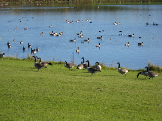
The route drops down from Ryhill to the village of Wintersett and then cuts through a field to the Anglers County Park.  Here you simply follow the path around the perimeter of the lake which was full of geese at this time of the year.

After the circuit of the lake the walk heads off for Haw Park Wood and the second section through the wood itself. Eventually this come out at the dam over Cold Hiendley Reservoir and, after crossing the road, follows the Barnsley Canal which, as well as being unused, must be the smelliest canal in England !.
The final stretch was a shady country path back up to Ryhill and the start/finish of the walk.
As for the rugby !  Well, I got horrendously lost in Barnsley and never found the ground. Despite asking for directions (including one person who claimed there was no rugby club in Barnsley) I spend 3/4 hour driving around in circles!  Hope the game was a good one and the result the right one !
Pictures available from the link

Saturday, 6 November 2010

Adel

Sunday, 31st October
11.1 Km (7.12 miles) -2hrs 10 mins

This walk is dedicated to the memory of my Great-Aunt Rose. Sadly, just as I was leaving Golden Acre Park I received a call to inform me that she had passed away at the age of 90.  A great lady who I have fond memories of.  She lived, for most of her life, as a farmer's wife in Garsdale.  A hard life in a Dales farm with little in the way of what we now take for granted - like an inside toilet ! She brought up three daughters and I have fond memories of visits and stays in the farmhouse - what it lacked in heating it made up for in the warmth of welcome.


The picture says it all !!  Wet and foggy this was more about walking, rather than looking at the scenery.  The walk came from a Leeds City Council website - unfortunately, I haven't kept the link.   The walk starts in Golden Acre Park busy even on a wet and misty morning with dog-walkers and families off to feed the birds in the park.  This route, however, head off through Breary Woods until you emerge past Pete's Pond (pictured above) and onto Cookridge Golf Course.
Thanks to the dog-walkers who put me on the right route the walk emerges on Holt Lane  and then across the very busy main road before heading across the fields to Adel Church. Again, a short walk along a road takes you into a uphill section through woods and alongside Headingley golf course.
The final section goes past Eccup Reservoir before cutting back through woods (Eccup Whin) and once more into Golden Acre Park and back to the car park.

Not a day for photographs but a few are available here

Around Derwent Water

Saturday, 23rd October
16.2 km (10.4 miles) - 3hrs 15min
The joys of the Lake District in autumn. The leaves on the trees are just starting to turn and, whilst the weather was not brilliant - it was overcast and dull - at least it did not rain.
Having been asked to spectate and select at Cumbria vs Northumberland U18 County Fixture, I took the opportunity to go the day before and completed a circuit of Derwent Water.  This is a well worn route and doesn't really need any description, in fact at times it was like walking down a High Street such were the numbers of people undertaking (I presume) the same route.
The route directions came from walkingworld.com and described the lake in an anti-clockwise direction heading out of Keswick and across to Portinscale before joining the lakeside path which is a well maintained and easily followed route. The bottom end of the lake is now another well maintained boardwalk before emerging onto the busy Borrowdale road by the Lodore hotel.
If I have any complaint about the route it was a little confusing on the return leg and I did find myself "paddling" in the water at one point.  However, I managed the longest walk to date this year in just over 3 hours.
As an afternote the next morning and the game were in brilliant, clear sunshine.  Keswick RUFC must be one of the prettiest rugby grounds in the U.K with Skiddaw dominating the scenery. Sadly, the rugby did not live up to the expectations but you can't have everything !

Some pictures from the link