Sunday 24 July 2011

Top Withens

Sunday, 24th July
9.44 k (5.8 miles) - 2hr 30 m
OS OL21 - South Pennines.

Glorious walking on a perfect summer's day.  When we actually got to Top Withens the views stretched for 20 or 30 miles !!
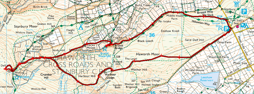
However, getting there proved to be the most difficult part as my Sat-Nav first wanted me to do a u-turn in the middle of a three lane road and then wanted to take me down a No Through Road - and I thought technology was there to help us.  Anyway the walk begins at a car park on Moor Side Lane (GR SE 018361). Immediately opposite the car park a track runs away to Drop Farm and is clearly marked to Top Withens.
The way is very straightforward with good, clear signs and shortly after the farm strikes out across the moor before meeting a good track that heads towards Harbour Lodge (GR SD 998353).  The path circumnavigates the farm and, after a short climb, contours around Harbour Hill before dropping down Crumber Dike.  At the bottom of the Dike the Bronte Way is encountered and the path  begins to climb towards the pinnacle of the walk, and its ultimate destination.

It has to be said that the last 1/2 mile or so are a pretty sharp climb up to the ruins of Top Withens itself.  Even though we had a reasonably early start there were plenty of people around to view what is, after all, only thought to have inspiration for a place in a book !!
We carried on slightly past the farm to grab our first cache of the day - transferring a "trackable" that had first started life in Western Australia via. the Druid's Temple to its current position !!

The other point of note (and one which all guide books make) is that the signs are duplicated in Japanese, although the one in the picture is the only one I saw and no Japanese were spotted to justify their existence !
Once Top Withens had been conquered we retraced our steps down the Bronte Way eventually grabbing our second cache of the day close to Bronte Bridge (GR SD 998358).  From there the path is straightforward, although signs of erosion, and led us back to the car and a more gentle journey back without the aid of Satellite Navigation !!
A fantastic walk on a day like today - it may be different in the depths of winter.  Usual set of photographs are available

Saturday 23 July 2011

Bingley and the 5 Rise Locks

Saturday, 23rd July
8.8 km (5.5 miles)
The inspiration for this walk will, for the time being, have to remain a mystery but we decided to do this relatively short walk which only took 1 1/2 hours, on a Saturday evening and what a bonus it turned out to be.
Firstly, the weather was aboslutely fantastic with hardly a cloud in the sky, although there was a chill wind which made it ideal for walking.  Secondly, who would have thought that the urban surroundings of Bingley - an old West Yorkshire factory town, could have provided such pleasing walking.

The walk started from the car park next to the Railway Station and, after a short distance along the Main Street cut off onto a path that skirted behind the houses and gave a real feeling of being away from it all. Having said that it was a case of "tiptoe through the dog p**" at times before emerging onto the road opposite Bradford & Bingley rugby club.

A skip across the bridge and a  gateway gives onto what looks like (and undoubtably is) someone's garden ! However, a clearly defined footpath skirts the manicured lawn and, for the next couple of miles the path hugs the banks of the River Aire and you feel as though you are truly out in the country, although looking upwards shows you the Aire Relief Road  zooming above you. 
As the footpath that follows the river dips away, the route takes you up and on to the towpath of the Leeds-Liverpool canal and over an aquaduct. From here it is a stroll back into the urban surroundings of Bingley passing one of Bingley's landmarks the Damart Factory. A short step on and you come to the world famous (?) 5 Rise Locks.  What always surprises me is the height that is gained in such a short distance.   After a trip to the top of the locks we turned and retraced our steps crossing the road by a footbridge to regain the car in the car park.   A wonderful, short walk which had plenty of interest and scenery.
Usual selection of photos are available from the link


Wednesday 13 July 2011

Ilton Moor & The Druids Temple

Wednesday, 13th July
16.4 km (10.2 miles) - 3hr 48 mins
Explorer 26 - Nidderdale.
Highs, lows and the bizarre. The walk starts near to an angler's parking spot next to Leighton Reservoir (GR SE 156787) a good 30 miles drive from home. The first stretch is along the road (surprisingly busy considering it's location and mid-week), until the access road to the reservoir is reached.  This was my last human contact until I got back to the car !!  The reservoir itself seems popular with anglers who lined the bank.
Eventually, you reach the dam across Roundhill Reservoir and,at the far end, head off up the moor. Here I had a distinct change of scenery as the path wound its way through heather and past a number of large boulders. The views across Arnagill and back to the reservoir were spectacular as height was gained. At the head of Arnagill the path meets a broad track (GR SE155753) mentioned in the guide book as an old monastic route.
This route is followed as it gradually rises to the highest point of the walk at Sandy Hill (356 mtrs) and long range views across to the Hambelton Hills and beyond !
After a further trudge across the moor a fork in the path descends to Ilton. The road then descends further to a bridge over Sole Beck before rising up the other side of the valley and access to Druid's Plantation and the Druid's Temple.  Before visiting the "Temple" I had time for a spot of lunch before bagging two Cache's including a "trackable" that I had taken from Pikedaw.
What can one say about the "Temple" - bizarre is one word. Apparently the folly was built just to keep the estate workers busy !  Long live English Eccentricity.
The final section drops from the plantation down to the bottom of the valley and across Pott Beck before a short climb to rejoin the road by the side of the reservoir and back to the car.
A delightful walk with the added interest of the folly and a couple of good "caches" along the way - that makes four for the week !  A selection of photos (as always) is available

Tuesday 12 July 2011

Pikedaw and Nappa Cross

Monday, 11th July
5.5 miles (8.9 km) - 3hrs 02
Map : OL2 - Yorkshire Dales, Southern and Western Areas
Pikedaw from Malham
A warm day and (eventually) a stiff walk with plenty of climbing involved!  Malham is, perhaps, best visited at this time of year, on a weekday when both parking and the crowds are diminshed and this was true for this walk.  At 11:00 a.m. on a Monday morning when everyone else was beavering away at their desks I ws able to park on the verge of the road as it enters Malham itself.
The walk commences along a track behind the National Park Car Park which runs parallel with the main street of Malham but, at the first opportunity, turns left and away from the village rapidly gaining height until it branches again by the Water Treatment Works and head straight for the first highpoint of the walk - Pikedaw.
Leaving the track you find yourself on lush pasture before the ascent begins. Whilst the main track skirts the side of Pikedaw, my goal was the cairn at the top, so from Hoober Edge I did just that and set my sights on the cairn and went straight up the side of the hill. This was about 100 metres of straight ascent and it really got the lungs and legs screaming for mercy !! The scramble was accompanied by increasing and more frequent stops but I determined and achieved the summit (surprisingly the Ordnance Survey does not give an actual height to Pikedaw itslef but is is around 430 mtrs).
As with all effort their was a reward and the most stunning views down Malhamdale itself were utterly spectacular and the photograph cannot and does not do it justice.

Here, believe it or not, I did my first bit of Geocaching of the day.  The clue read "Nobby's cross - which will make sense when you see it". Never was a truer word written.  In true Ronseal style the clue did what it said on the tin.
From the cairn and it wonderful views the walk then heads unerringly upwards to a gate at GR SD 874639.
Through the gate the map marks the location of Nappa Cross - a "waymark" on a monk's trail. Sadly, I did not find this, although I did bag my second cache of the day !
The next stretch of the walk descends gently, with views of Malham Tarn to a crossroads which again allows you to descend to the very top of Watlowes - the "dry valley". Instead of dropping into the valley the route tracks along the top side -with views of the limestone pavement on the top of the Cove until reaching a road. A few steps up the road and a gate leads across the field to a lane which eventually meets your outward track by the Water Treatment Works.  Malham is soon regained and the end of a thoroughly enjoyable walk and a well earned rest !!
As usual I attach a selection of photographs

Sunday 3 July 2011

Down the Ure, Up the Swale

Sunday, 3rd July 2011
12.3km (6.7 miles) - 2hrs 55 mins
High summer has arrived !!  This was, thankfully, not a strenuous walk as temperatures hit 23 degrees centigrade.  It was also an easy walk to follow as the title suggests.
Starting from Boroughbridge's main car park, where the parking is FREE! (always a bonus for a tight-wadded Yorkshireman) the route follows the River Ure downstream from the bridge in the centre of the town.  This was pleasant walking, on the level just above the slow flowing river and took in Milby Lock, where a "cut" has been manufactured to allow boats upstream (eventually reaching Ripon).  Just beyond the lock Gill found the first "cache" of two we discovered that day.
 Eventually the route reaches the confluence on the River Swale, although there is hardly a conflict between the two rivers who seem to meander together rather than compete with each other.
Here the route turned up the bank of the Swale until we reached Myton Bridge - a remarkably sturdy and ornate structure that seems to lead from nowhere to nowhere !
Here you cirmcumnavigate the site of the Battle of Myton, also known as the White Battle. Fought in 1319 between the Scots and an army raised by the Archbishop of York, it turned out to be a one-sided affair in favour of the Scots with the English army, which contained many clerics (hence the alternative title) suffering huge losses.
After a circuit of the site, which is now a battle between broad beans and wheat !! A stretch along a quiet country lane was in direct contrast with a section along a frighteningly busy road to reach Milby.  A short walk brought us back to Milby Lock and a quick stride back into Boroughbridge.
A pleasant walk on a very pleasant day, and whilst it may have lacked the spectacular views of the Dales it did afford us long distance views across to the White Horse of Kilburn.
Usual display of photographs available from the link.